Golden Evergreen 1:45,000 scale
1st Edition |
|

|

|
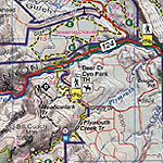
New map covers a big chunk of the greater Denver foothills. This is large country with plenty of good and even great trails for everyone. See Front Cover for map coverage. We used 8 different sets of road and trail data and our own GPS to produce the most accurate, detailed and up to date map of the area. And at $8.95 the compact, yet full, map is the absolute best value and highest quality. As some mountain bikers have commented: “You really do have every single switchback!”
Some of the well known and very nice areas mapped include Alderfer / 3 Sisters, Apex, Centennial Cone, Clear Creek Canyon, Deer Creek Canyon, Denver Mtn Parks, Elk Meadow, Flying J, Golden Gate State Park, Lair o the Bear, Lookout Mtn, Myers Ranch, Mt Falcon, Red Rocks, Table Mtns, White Ranch & Much More...
Map Features:
- 50ft contours; Enlightened Shaded Relief reveals the rugged terrain.
- All trails rated for difficulty; mileage between junctions mapped. Plus mileage for some big loops shown.
Singletrack mapped.
- Hiking, road biking, mountain biking, fishing, climbing, hunting, camping, white water, horseback, 4wd, and motorsports information.
- Folds to 4 x 6.75 inches
|